
The ancient harbour of Paphos was most likely built during the Hellenistic period when the capital of the ancient kingdom of Paphos was transferred to Nea Paphos (today’s Kato Paphos) at the end of the fourth century BC.

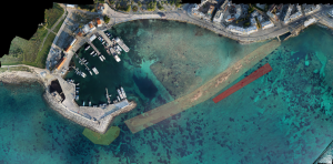
Aerial Map showing the location of the harbour of Kato Paphos (ESRI.WorldImagery view; Image composition: M. Secci; © MARELab).
The characterisation of the harbour as Kleistos Limen is associated with its narrow entrance (55m) and the fortification that possibly extended on the moles. Paphos kept its importance during the Roman period as a seat of a Roman Proconsul. Part of the western side of the harbour, protected by the Saranta Kolones castle, must have been used during the Byzantine, Frankish and Venetian periods. It was also used during the Ottoman period when the castle we see nowadays was built, probably on the foundation of one of the Hellenistic towers protecting the ancient harbour. Dredging works by the British Colonial Government destroyed the upper part of the eastern mole, most probably in 1909-1911. The current top surface over the last 155 m of its length belongs to its foundation and is currently at – 2.5 m. A systematic development programme began in 1989 by the Ports Authority of Cyprus, which included: the construction of a new quay, the enhancement of the breakwater and the reconstruction of the sea front along the north-western part of the port (https://www.cpa.gov.cy/en/pafos-port).
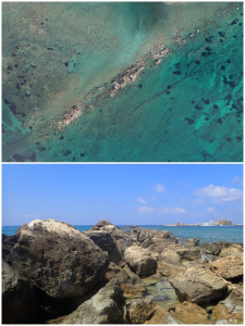
The ancient breakwaters of the ancient harbour of Kato Paphos: the eastern one is shaded in pale yellow, the western one is shaded in pale green, and the external one in pale red (Drone survey and orthophoto: CUT; Image composition: M. Secci; © MARELab).
The western mole of the ancient harbour was then covered by modern constructions for its most part. A survey was conducted by MARELab in 2021 under the direction of Dr Stella Demesticha, the coordination of Dr. Massimiliano Secci and specialized consultancy by Dr. Theotokis Theodoulou, as well as the participation of MARELab collaborators.
Aerial view and detail of the Eastern Mole section that is still visible above the water. (Drone survey and orthophoto: CUT; Photograph: S. Demesticha; © MARELab).
The survey was ordered and funded by the Cyprus Ports Authority prior to planned harbour works at the immediate vicinity of the ancient harbour. The ancient harbour basin can be divided into two main parts, based on its modern uses and function: the eastern half, which is silted and mostly undisturbed and the western half, which has been used as a harbour throughout the 20th century, with several phases of inventive harbour works on the coast and underwater.
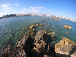
Eastern Mole, view from west to east (Photo: Th. Theodoulou; © MARELab).
The harbour of Kato Paphos is a very particular case of an ancient harbour site, fully incorporated into the life and economy of the modern town and with a part of it functioning as a marina. Despite the documented interventions and destruction from antiquity to the recent decades, it has maintained an important part of the structures related to harbour activities that developed over the centuries.
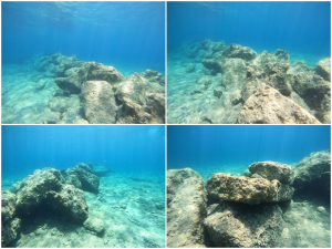
External Breakwater: note the large boulders meant to sustain the force of the sea currents (Photos: Th. Theodoulou; © MARELab).
PRELIMINARY APPLICATION IDEA
The application idea consists of an interactive timeline describing both the natural- and human-driven changes to the harbours landscape. The application will offer a timeline “through the visitors’ eyes”, offering a history of the harbour. It was built during the Hellenistic period, becoming a relevant harbour with the transfer of the capital of the ancient kingdom of Paphos from Palaepaphos to Nea Paphos at the end of the 4th century BC. In Roman times it was the seat of a Proconsul, becoming the main harbour of the island and reaching its peak. During the Medieval times there was a decline. These historical moments are characterized by specific changes in the landscape (i.e., the construction of the harbour, the addition of a secondary breakwater, the construction of the Castle etc.). Useful sources to produce such timeline will be archaeological and historical studies but also texts and accounts from visitors and travelers through the ages. The timeline will start from today and will allow the user to step back in time and see when specific monuments and changes in the landscape occurred.
![]()
Last Updated on June 24, 2022