
The MARELab has been involved with the harbour of Amathus as part of the Andikat Project (https://andikat.eu/) with the aim to create the first underwater archaeological park in Cyprus. The location of Amathus, on a coastal hill with an unobstructed view of Lemesos (Limassol) Bay, facilitated the active involvement of its inhabitants in international seaborne trade networks.
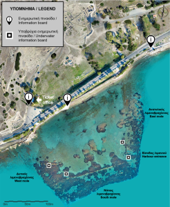
The positions of the terrestrial and underwater information boards at the harbour of Amathus (© University of Cyprus, MARELab. Created using orthophoto published in Skarlatos & Savvidou 2015: fig. 3, courtesy of Dr D. Skarlatos © Cyprus University of Technology).
The earliest testimonies of overseas contacts may be seen on finds dating to the Early Iron Age (10th century BCΕ): rich deposits of imported pottery from the Levant were found in the area, as well as the earliest evidence so far of imported vessels from Euboea, in the Aegean. A depression on the coastline that formed a natural cove was probably used as the town’s first harbour.
The depression on the coastline, southeast of the ancient Agora, formed a natural cove that was probably used as the town’s first harbour (I. Katsouri, M. Secci © University of Cyprus, MARELab. Created using: (i) Photogrammetric 3D model published in Skarlatos & Savvidou 2015: fig. 3, courtesy of Dr D. Skarlatos © Cyprus University of Technology; (ii) Plans of the Acropolis and Agora © French School at Athens).
A significant number of clay ship models, found in tombs and in the sea, attest to an increased maritime activity at the town, at least during the Archaic period (7th to 6th centuries BCE). Today, that inner harbour is totally ‘invisible’ since gradual silting during the Hellenistic period (3rd to 1st centuries BCE) led to an extensive progradation of the coast towards the sea. The outer harbour of Amathus is dated to the beginning of the Hellenistic period, around the end of the 4th century BCE. It has been suggested that it was constructed between the years 312/311 and 294 BCE, during a period when Cyprus became an arena of conflict between two powerful successors of Alexander the Great.
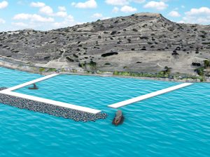
Hypothetical simplified reconstruction of the harbour of Amathus (I. Katsouri © University of Cyprus, MARELab. Created using: (i) Photogrammetric 3D model published in Skarlatos & Savvidou 2015: fig. 3, courtesy of Dr D. Skarlatos © Cyprus University of Technology; (ii) 3D models of an Athenian Trireme and of the Kyrenia ship © 2018 iMARECULTURE project).
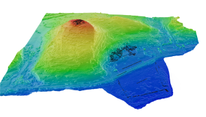
As life in Amathus continued normally until Late Antiquity (5th to7th centuries CE), the harbour was probably used for small-scale maritime activities following its silting. Following the Arab raids in the mid-7th century CE, Amathus was gradually abandoned, and the urban centre was transferred farther west, to Theodosias/Neapolis/Nemesos (later Lemesos [Limassol]). Between 1984 and 1986, a team of the French School at Athens under the direction of the French archaeologist Jean-Yves Empereur undertook one of the first harbour excavations in the eastern Mediterranean. Today, the harbour of Amathus is among the best-preserved ancient port sites in the eastern Mediterranean, it has been included in a protected marine area and is currently used for water sports. It still attracts human activity, no longer by mariners, craftsmen, or plunderers, but by walkers and swimmers, who seek to engage with the sea through leisure, thus adding a new chapter to the long history of the Amathusian coast. As part of the ANDIKAT Project, the underwater remains of the harbour have been thoroughly recorded with 3D photogrammetry, allowing to produce a 3D model of the structures.

The location of the harbour structures visualized on the drone orthophoto (1); and (2) the underwater photogrammetry 3D model of the submerged structures (Drone and underwater photogrammetry: CUT; Image composition: Massimiliano Secci; © MARELab).
Further info: https://www.ucy.ac.cy/marelab/en/research/andikat-project
PRELIMINARY APPLICATION IDEA
Several short videos, intended for the general public, will be created as a way to present different aspects of the research and study of the ancient harbour of Amathus. Such aspects include: a) the architecture of the harbour, b) the sea level changes and c) the coastline changes. In addition to the photogrammetric data of the harbour remains, the videos will use as a basis, the visual material (maps, images and 3D models) and the textual information compiled for the “Amathus Harbor” application.
![]()
Last Updated on June 24, 2022